Official opening program for the new educational trail (19 september 2014)

Prospekt News


Photo 1. Panel located at the start of the educational trail Baška – Zarok
– Batomalj – Pod Lipicu

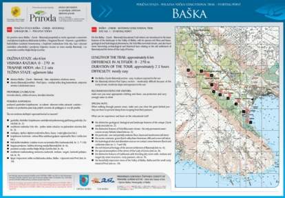
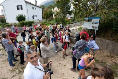
OFFICIAL OPENING PROGRAM FOR THE NEW EDUCATIONAL TRAIL (19 September 2014)

  • 9 a.m. – opening of the trail at the bridge in the direction of Zarok
    – a walk along the 6 kilometre-long trail
  • 10.30 a.m. – arrival at the town square in Batomalj; participants
    will be welcomed by the representative of the Local Administrative Office
    of Batomalj; brief introduction to Batomalj by Romina Fantov, chairwoman
    of the Local Administrative Office; visit to the Church of St. Nicolas,
    refreshments
  • 11.30 a.m. – a walk to the Shrine of Our Lady of Gorica; visit to
    the Church of Our Lady of Gorica; brunch.

If they wish, participants may continue along the trail
to Jurandvorski Mrgar and Pod Lipicu.

Organizers:
Baška Municipality Tourist Board
Batomalj Local Administrative Office
Public Institution “Priroda”
Baška Tourist Association
Shrine of Our Lady of Gorica

CONTENTS OF EDUCATIONAL PANELS (100 x 70 cm) ALONG THE
TRAIL BAŠKA-ZAROK-BATOMALJ-POD LIPICU

  1. INITIAL PANEL – START OF THE TRAIL – This panel describes the trail’s
    basic characteristics – its length, level of difficulty, and time required
    – and features a map showing the trail and the locations of interpretation
    panels along its length.
  2. ZAROK – The panel at Zarok tells us about the primary geological and
    botanical features of the sandbeds (events in glacial and interglacial
    periods, the effects of ice sheets and torrents, how sand and gravel
    deposits were formed). Geological information was provided by expert
    geologists (Ljerka Marjanac PhD).
  3. MURVAC – VELA RIKA – This panel explains the basic features of the
    water course Vela Rika – its plant and animal life and its hydrology
    – and tells us about landscape use in the Vela Rika valley along its
    torrent-carved bed.
  4. POD VISOKU – This panel describes the traditional way of life in the
    past and the agrarian landscape of Bašćanska Valley. It provides basic
    information about the three “levels” of the landscape: 1.
    the fertile alluvium of Vela Rika, 2. the surrounding flysh slopes,
    and 3. the limestone escarpments and plateaus in the upper part of the
    valley.
  5. POD JABUKE – at the water tap – The panel focuses on the characteristics
    and diversity of flysh landscapes in Bašćanska Valley and describes
    the sources and contrasts of limestone cliffs and denuded karst plateaus.
  6. BATOMALJ – This panel describes the history of settlements using archaeological
    facts (in collaboration with Ranko Starac).
  7. PERILO – The panel describes how the water springs and wash basins
    were used at Batomalj (in collaboration with the Batomalj Local Administrative
    Office).
  8. TOWARDS THE SHRINE – The panel uses archaeological facts to describe
    the landscape of Gorica Hill and the shrine (Ranko Starac).
  9. JURANDVORSKI MRGAR – The panel tells about the basic facts of rural
    life, sheep-farming and drystone sheepfolds called mrgari.
  10. POD LIPICU – The panel provides interesting facts pertaining to the
    geological and biological heritage (flora and fauna) of the part of
    Bašćanska Valley that is teeming with steep cliffs and screes located
    above flysh slopes. Emphasis is placed on the importance that traditional
    animal husbandry has in landscape conservation.

INFORMATIVE PLATES (30 x 10 cm)

  • 11. ENDEMIC ISTRIAN BLUEBELL
  • 12. RECONSTRUCTED MOŠUNA AT BATOMALJ


Photo 2. The official opening of the trail. Participants gather at the
“Pod Jabuku” educational panel at Batomalj (Photo by Srđan Hulak
from the photo archives of Baška Tourist Board)