| SPATIAL DATA CONCERNING NATURE PROTECTION In 2014, the State Institute for Nature Protection (SINP)
plans to launch a nature-protection information system Geoportal which
will enable public access to spatial data concerning biological diversity
and nature protection in Croatia. Until the Geoportal is set up, some
data are available in the form of Web cartographic browsers. Natura 2000 This Web application has been in place for some time
on the official Web site of the Natura 2000 network in Croatia. To access
it, click here. What is new is that data can now be accessed for each
individual location. By clicking on an area, a window appears offering
a link to Natura 2000 standard data forms. Below is an example of how
this looks for the Natura 2000 areas of Gorski Kotar and northern Lika: 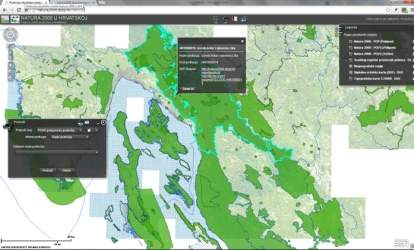
A click on the link SDF (Standard Data Form) Report opens
up a window that provides data on any Natura 2000 area. 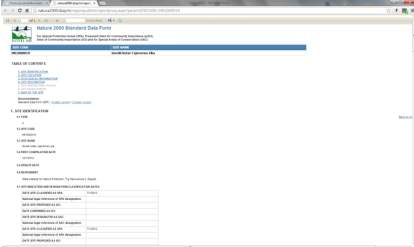
Map of protected areas in Croatia SINP has set up and regularly maintains a database of
protected areas in Croatia. The database contains the boundaries of protected
areas in the categories of protection stipulated by the Nature Protection
Act. These categories are strict reserve, national park, nature park,
special reserve, regional park, natural monument, important landscape,
forest park and monument of park architecture. To access the interactive
Web map of protected areas, click here,
From the SINP
Web site you can also download GIS programme services. 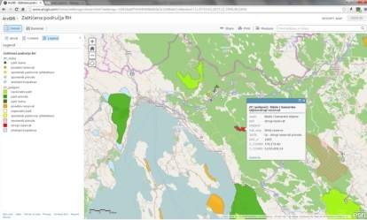
The Web browser also lets you choose a specific area
and then displays the area’s basic data. Habitat map of Croatia A habitat map of Croatia is available at the SINP Web
site. The habitat map is a GIS database on the distribution of habitat
types in Croatia. The map is built in a scale of 1:100,000, with a minimum
mapping unit of 9 hectares. By using the legend next to the map and clicking
on an area, you can open a window with the habitat type name and code.
Web applications can be viewed here,
and from the SINP
Website you can also download GIS programme services. This is what the habitat map for the Rijeka environs
looks like: 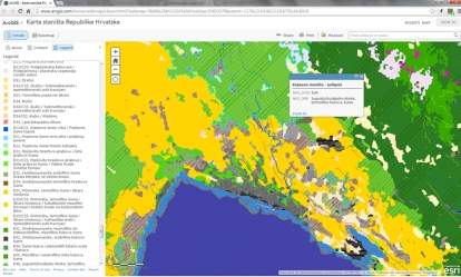
Instructions for adding and reviewing Web services for
all three maps on GIS desktop programmes can be found at the State
Geodetic Administration GeoPortal. WMS and WFS services can
be downloaded from the Natura 200 Web site (for the Natura 2000 environmental
network) and from the SINP Web site (for the habitat map and protected
areas map). | 
